태풍은 어떻게 형성됩니까?
How are typhoons formed?
Typhoon it's just a tropical cyclone It occurs in areas where the pressure is too low. In practice it is the same than a hurricane, what happens is that it is called a typhoon if it occurs in the western pacific zone. In the event that it occurs in the eastern Pacific it is called a hurricane.
태풍은 열대성 저기압인데 기압이 너무 낮은 지역에서 발생합니다. 실제로는 허리케인과 동일하며, 서태평양 지역에서 발생하면 태풍이라고 합니다. 동태평양에서 발생하면 허리케인이라고 합니다.
Studies show that a typhoon is created, when an atmospheric wave found in the Pacific rotates following the planet's own rotation. This will generate high pressures on the outside and low pressures in the middle. If this phenomenon continues to rotate at a speed of about 120 km / h it can be said that it is a typhoon.
연구에 따르면 태풍은 태평양에서 발견되는 대기파가 행성의 자전을 따라 회전할 때 생성됩니다. 이것은 외부에 고기압을 생성하고 중간에 저기압을 생성합니다. 이 현상이 약 120km/h 의 속도로 계속 회전한다면 태풍이라고 할 수 있습니다.
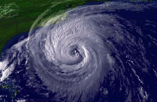
They occur over warm seas and bring powerful thunderstorms, heavy rainfall, and storm force winds. The name "tropical cyclone" is scientific. Depending on the part of the world, they are simply called hurricanes (United States and Latin America) and typhoons (Asia and Australia).
그들은 따뜻한 바다에서 발생하며 강력한 뇌우, 폭우, 폭풍우 바람을 가져옵니다. "열대 저기압"이라는 이름은 과학적입니다. 지역에 따라 단순히 허리케인(미국과 라틴 아메리카)과 태풍(아시아와 호주)이라고 합니다.
Tropical cyclones are "fed" with warm and humid air. They form over the ocean due to hot temperatures and water that evaporates from the surface of the ocean. Warm humid air rises, creating a "deficit" of air near the surface. In its place new air comes, which also heats up and rises. This process takes up more and more territory. Due to the constant flow of humid and warm air, cloudiness is intensely formed, precipitation falls, and the wind increases.
열대성 저기압은 따뜻하고 습한 공기를 공급합니다. 그들은 뜨거운 온도와 바다 표면에서 증발하는 물 때문에 바다 위에 형성됩니다. 따뜻하고 습한 공기가 상승하여 표면 근처에 공기 결손을 만듭니다. 그 자리에 새로운 공기가 들어오고 이 공기도 뜨거워지고 상승합니다. 이 프로세스는 점점 더 많은 영역을 차지합니다. 습하고 따뜻한 공기의 지속적인 흐름으로 인해 구름이 강하게 형성되고 강수량이 떨어지고 바람이 강해집니다.
As air warms over the ocean, it expands, becomes lighter and rises. Other local winds blow in to replace the air that has risen, which in turn warms and also rises. The rising air contains a huge amount of moisture evaporated from the ocean surface.
As it rises the air cools, and the moisture condenses to form huge clouds about 10 km up in the troposphere.
바다 위에서 공기가 따뜻해지면, 그것은 팽창하고 가벼워지고 상승합니다. 상승한 공기를 대체하기 위해 다른 국지풍이 불어와서 따뜻해지고 또한 상승합니다. 상승하는 공기에는 해수면에서 증발된 엄청난 양의 수분이 포함되어 있습니다.
위로 올라가면 공기가 식고 수분이 응결되어 대류권에서 약 10km 상공에서 거대한 구름을 형성합니다.
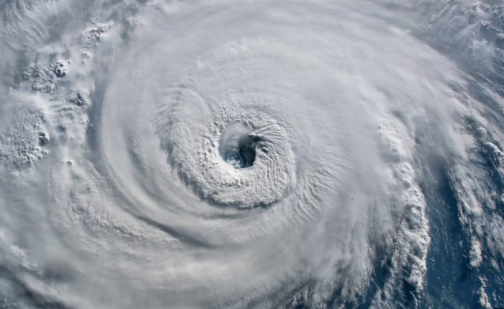
More warm air rushes in and rises, drawn in by the draft above. The rising drafts of air carry moisture high into the atmosphere which causes the clouds to become very thick and heavy.
더 많은 따뜻한 공기가 밀려오고 위의 외풍에 이끌려 올라갑니다. 상승하는 기류는 습기를 대기 중으로 운반하여 구름이 매우 두껍고 무거워지게 합니다.
Condensation then releases the latent heat energy stored in the water vapour, providing the typhoon with more power. This creates a self-sustaining heat cycle.
응축은 수증기에 저장된 잠열 에너지를 방출하여 태풍에 더 많은 힘을 제공합니다. 이는 자체적인 열 순환을 만듭니다.
The force created by the earth’s rotation on a tilted axis, (the Coriolis Effect), causes rising currents of air to spiral around the centre of the typhoon. It’s at this stage that the typhoon matures, and the eye of the storm is created.
As the air rises and cools, some of the dense air descends to form the clear still eye as the typhoon rages around it.
The eye wall where the wind is strongest behaves like a whirling cylinder, (typhoons rotate anti-clockwise in the northern hemisphere).
지구가 기울어진 축을 중심으로 자전하면서 발생하는 힘(코리올리 효과)으로 인해 상승기류가 태풍 중심을 중심으로 나선형으로 형성되며, 이 단계에서 태풍이 성숙되어 폭풍의 눈이 생성됩니다.
공기가 상승하고 냉각되면서 태풍이 주변을 휘젓고 있을 때 밀도가 높은 공기 중 일부가 하강하여 맑은 고요한 눈을 형성합니다.
바람이 가장 강한 안벽은 소용돌이치는 원통처럼 움직입니다(태풍은 북반구에서 시계 반대 방향으로 회전합니다).
As warm ocean water feeds it heat and moisture the typhoon usually continues to enlarge.
A tropical cyclone loses its strength when it is no longer in contact with the warm and humid surface of the ocean. For example, if it passes over a cold current, or goes to land, it will weaken and begin to collapse.
따뜻한 바닷물이 열과 습기를 공급함에 따라 태풍은 보통 계속 확대됩니다.
열대성 저기압은 더 이상 따뜻하고 습한 바다 표면과 접촉하지 않으면 힘을 잃습니다. 예를 들어 차가운 해류를 통과하거나 육지로 가면 약해지고 붕괴되기 시작합니다.
 홈 > 영어컨텐츠 > Today's Issue